


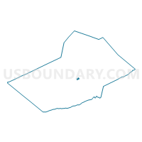
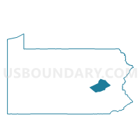
PALO ALTO WD 01, Schuylkill County, Pennsylvania
About
Outline

Summary
| Unique Area Identifier | 663727 |
| Name | PALO ALTO WD 01 |
| County | Schuylkill County |
| State | Pennsylvania |
| Area (square miles) | 0.39 |
| Land Area (square miles) | 0.39 |
| Water Area (square miles) | 0.00 |
| % of Land Area | 100.00 |
| % of Water Area | 0.00 |
| Latitude of the Internal Point | 40.68176890 |
| Longtitude of the Internal Point | -76.18113630 |
Maps

Graphs
Select a template below for downloading or customizing gragh for PALO ALTO WD 01, Schuylkill County, Pennsylvania


Neighbors
Neighoring Voting District (by Name) Neighboring Voting District on the Map
- MECHANICSVILLE Voting District, Schuylkill County, PA
- NORTH MANHEIM TWP DIST MELLOTS PCT 02, Schuylkill County, PA
- NORTH MANHEIM TWP DIST PCT 01, Schuylkill County, PA
- PALO ALTO WD 02, Schuylkill County, PA
- PORT CARBON Voting District, Schuylkill County, PA
- POTTSVILLE WD 02 PCT 09, Schuylkill County, PA
Top 10 Neighboring County Subdivision (by Population) Neighboring County Subdivision on the Map
- Pottsville city, Schuylkill County, PA (14,324)
- North Manheim township, Schuylkill County, PA (3,770)
- Port Carbon borough, Schuylkill County, PA (1,889)
- Palo Alto borough, Schuylkill County, PA (1,032)
- Mechanicsville borough, Schuylkill County, PA (457)
Top 10 Neighboring Place (by Population) Neighboring Place on the Map
- Pottsville city, PA (14,324)
- Port Carbon borough, PA (1,889)
- Palo Alto borough, PA (1,032)
- Mechanicsville borough, PA (457)
Top 10 Neighboring Unified School District (by Population) Neighboring Unified School District on the Map
Top 10 Neighboring State Legislative District Lower Chamber (by Population) Neighboring State Legislative District Lower Chamber on the Map
Top 10 Neighboring State Legislative District Upper Chamber (by Population) Neighboring State Legislative District Upper Chamber on the Map
Top 10 Neighboring 111th Congressional District (by Population) Neighboring 111th Congressional District on the Map
Top 10 Neighboring Census Tract (by Population) Neighboring Census Tract on the Map
- Census Tract 32, Schuylkill County, PA (5,539)
- Census Tract 20, Schuylkill County, PA (3,644)
- Census Tract 17, Schuylkill County, PA (3,173)
- Census Tract 22, Schuylkill County, PA (2,752)
- Census Tract 21, Schuylkill County, PA (1,489)